Unlock Features
Use Unlock Feature to release the select features in the spatial database and optionally to discard any changes that were made to those features.
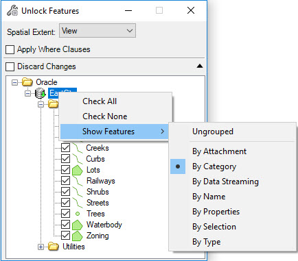
Selecting the Unlock tool opens the Unlock Features dialog with all features selected. Check the boxes to lock the desired features. Right-click the connection name to Check All, Check None, or to Show Features organized by one of several options.
If a Fence is active in the current session, the Spatial Extent will be set to Fence. If there is no Fence present, the Spatial Extent will be set to View. To unlock all features select All.
- Apply Where Clauses – Will apply any Where Clauses defined in the Connection dialog. Uncheck to post modified features without applying the Where Clause.
- Continue on Error – Continues posting even if an error is encountered during the post process.